
How to draw the border between two countries
Every day this page asks you to draw the border between four pairs of neighbouring countries. Each pair is merged into one shape with the shared line erased, and each name is printed on its own side. You draw the border between them from memory: one line, from where it starts to where it ends, without the coastline or any other frontier.
Use the pen to draw the border between the two names in one stroke or several. Strokes whose ends meet are joined; if you leave a gap, the longest piece counts and nearby pieces are attached to it. Press Done and the real line appears on top of yours.
After the four daily pairs, press Practice more to draw the border between random neighbours with no limit. There are 198 pairs, each sharing one continuous land border of at least 150 km. Your daily total is out of 400, and the share card shows your lines and scores without giving the answers away. It is the quickest way to learn whether you can draw the border between two countries you thought you knew.
How a border line is scored

When you draw the border between two countries, your score out of 100 has two parts:
- Closeness, 85%. Points along the real border are compared with points along your line, and the average gap is measured in kilometres on the globe. It is judged against the border's length, so when you draw the border between neighbours with a short border, every kilometre counts for more.
- Ends, 15%. Start and finish where the real line does. Direction doesn't matter, so you can draw the border between them from either end.
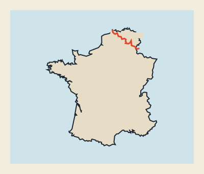
In the example above, a player tried to draw the border between Belgium and France and put the line about 47 km to the side of the real 465 km border. The real line wiggles, so the average gap is only ≈ 37 km, and the line scores 60. Each time you draw the border between a pair you also get a title, from Cartographer at 85 or more down to Lost.
Where to draw the border between countries with a ruler

We ranked the pairs by the share of their border made of straight stretches like these. The five easiest places to draw the border between neighbours with a ruler:
- Libya – Chad, 100% straight (1051 of 1051 km). Three ruler lines across the Sahara, two of them over 400 km.
- Algeria – Niger, 100% straight (952 of 952 km). Four straight legs across the desert: learn the three angles.
- Oman – Saudi Arabia, 100% straight (658 of 658 km). To draw the border between Oman and Saudi Arabia, learn where it turns in the Empty Quarter.
- Algeria – Mauritania, 100% straight (462 of 462 km). A single straight line: one stroke with a ruler.
- Oman – Yemen, 98% straight (284 of 292 km). To draw the border between Oman and Yemen, run one diagonal from the Arabian Sea coast up into the desert.
When you draw the border between Saharan or Arabian neighbours, expect lines like these: treaties there used surveyors' lines because there were no rivers or ridges to follow. But the angle matters: if you draw the border between Libya and Chad just 5° off, the far end lands about 92 km from where it should.
The most winding borders

At the other end of the scale are borders that wander. We divided each border's length by the straight-line distance between its two ends: the higher the number, the harder it is to draw the border between the two. The top five:
- Gambia – Senegal, 11.9×. 732 km long, yet both ends sit on the Atlantic coast only about 62 km apart. To draw the border between Gambia and Senegal, go inland along one side of the Gambia River and come back along the other.
- Eswatini – South Africa, 4.31×. South Africa wraps around Eswatini on three sides, so the line is a hook, not a stroke.
- Mozambique – Malawi, 4.19×. 1393 km. Malawi's southern tail pushes deep into Mozambique: to draw the border between Mozambique and Malawi, run down one side of the tail and back up the other.
- Kyrgyzstan – Uzbekistan, 4.07×. The Fergana Valley is shared by three countries; to draw the border between Kyrgyzstan and Uzbekistan, zigzag round its rim.
- Kyrgyzstan – Tajikistan, 3.21×. Another Fergana Valley line, full of sharp bends.
To draw the border between neighbours like these, find both ends first, then the big turns, and don't chase every wiggle. The score uses the average gap, so the overall path matters more than each bend.
Tips to draw the border between neighbours
- Find the ends. Before you draw the border between any pair, find where the line must start and stop: on a coast or where a third country joins. The ends are worth 15% on their own.
- Follow rivers. To draw the border between Finland and Sweden, follow the Torne and Muonio rivers for most of the way. To draw the border between Mexico and the United States, follow the Rio Grande from the Gulf of Mexico to El Paso, then go west in straight lines.
- Follow mountains. To draw the border between Argentina and Chile, trace the crest of the Andes along most of the 4792 km line. To draw the border between Norway and Sweden, follow the Scandinavian mountains along most of the 1590 km line.
- Use latitude lines. 66% of the line between Canada and the United States is straight, most of it on the 49th parallel. When you draw the border between them, skip the ruler: on this equal-area map the 49th parallel is a gentle arc that rises toward the Pacific.
For whole outlines, try the daily Draw the Border game or pick any country in Country Draw. Then come back tomorrow to draw the border between four new pairs.
Draw the border between countries: FAQ
What does “draw the border between” two countries mean here?
Two neighbouring countries are merged into one shape with their shared border removed. You draw the single line that separates them.
How is a border line scored?
We measure the average gap between your line and the real border in kilometres and compare it with the border’s length; 15% of the score comes from starting and ending in the right places.
Which pairs of countries appear?
Neighbours that share one continuous land border of at least 150 km. Pairs involving disputed borders are left out.
How do I draw the border between 2 countries on a phone?
One finger draws the line; a quick upward or downward flick scrolls the page instead. Two fingers zoom, and the ⤢ button opens a full-screen map.
Is this draw the border between countries game free?
Yes. No account, no download and no limit on Practice more.
Can I play more than four borders a day?
Yes. After the daily four, press Practice more for unlimited random pairs.
Can I draw the border between any two countries?
Any two non-disputed neighbours that share a land border of at least 150 km, 198 pairs in all; Practice more picks from all of them.
Why can’t I draw the border between Russia and China?
Both have disputed borders elsewhere, and any pair that includes a country with a disputed border is left out of this mode.